
Make a donation
Gear up for your next adventure:
As an Amazon Associate, this site earns from qualifying purchases at no extra cost to you.
Salamina topographic map
Click on the map to display elevation.
Make a donation
Gear up for your next adventure:
As an Amazon Associate, this site earns from qualifying purchases at no extra cost to you.
Salamina
Extensión total: 40.354,94 ha Extensión área urbana: 79,69 ha Extensión área rural: 40.245,96 ha Altitud de la cabecera municipal: 1822 m s. n. m. Temperatura media: 22 °C Distancia de referencia: 75 km de Manizales
Make a donation
Gear up for your next adventure:
As an Amazon Associate, this site earns from qualifying purchases at no extra cost to you.
About this map
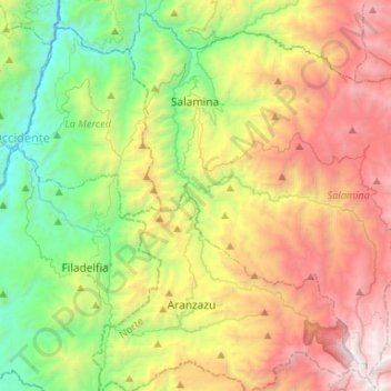
Name: Salamina topographic map, elevation, terrain.
Location: Salamina, Norte, Caldas, RAP del Agua y la Montaña, Colombia (5.22237 -75.53203 5.46701 -75.26943)
Average elevation: 1,931 m
Minimum elevation: 674 m
Maximum elevation: 3,795 m
Make a donation
Gear up for your next adventure:
As an Amazon Associate, this site earns from qualifying purchases at no extra cost to you.
Other topographic maps
Click on a map to view its topography, its elevation and its terrain.
Parque de la Mujer
Colombia > Caldas > Manizales > Perímetro Urbano Manizales
Average elevation: 2,072 m
Make a donation
Gear up for your next adventure:
As an Amazon Associate, this site earns from qualifying purchases at no extra cost to you.