
Make a donation
Gear up for your next adventure:
As an Amazon Associate, this site earns from qualifying purchases at no extra cost to you.
Kensington topographic map
Click on the map to display elevation.
Make a donation
Gear up for your next adventure:
As an Amazon Associate, this site earns from qualifying purchases at no extra cost to you.
About this map
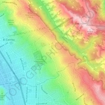
Name: Kensington topographic map, elevation, terrain.
Average elevation: 164 m
Minimum elevation: 3 m
Maximum elevation: 356 m
Make a donation
Gear up for your next adventure:
As an Amazon Associate, this site earns from qualifying purchases at no extra cost to you.
Other topographic maps
Click on a map to view its topography, its elevation and its terrain.
Mount Diablo State Park
United States > California > Contra Costa County > Clayton
Mount Diablo is a mountain of the Diablo Range, in Contra Costa County of the eastern San Francisco Bay Area in Northern California. It is south of Clayton and northeast of Danville. It is an isolated upthrust peak of 3,849 feet (1,173 meters), visible from most of the San Francisco Bay Area. Mount Diablo…
Average elevation: 334 m
Bayview-Montalvin
United States > California > Contra Costa County > Pinole > Gateley
Average elevation: 17 m
Camino Tassajara
United States > California > Contra Costa County > Camino Tassajara
Camino Tassajara (Spanish for "Path of Carne Seca") is a census-designated place in Contra Costa County, California. Camino Tassajara sits at an elevation of 814 feet (248 m). The 2010 United States census reported Camino Tassajara's population was 2,197.
Average elevation: 233 m
Make a donation
Gear up for your next adventure:
As an Amazon Associate, this site earns from qualifying purchases at no extra cost to you.
Tilden Regional Park
United States > California > Contra Costa County > Orinda
Average elevation: 273 m
Morgan Territory Regional Preserve
United States > California > Contra Costa County
Average elevation: 449 m
Make a donation
Gear up for your next adventure:
As an Amazon Associate, this site earns from qualifying purchases at no extra cost to you.
Lafayette Reservoir
United States > California > Contra Costa County > Lafayette
Average elevation: 174 m
John Muir National Historic Site
United States > California > Contra Costa County > Martinez > Muir
Average elevation: 94 m
Make a donation
Gear up for your next adventure:
As an Amazon Associate, this site earns from qualifying purchases at no extra cost to you.
Eugene O'Neill National Historic Site
United States > California > Contra Costa County > Alamo
Average elevation: 237 m