
Aubrey topographic map
Interactive map
Click on the map to display elevation.
About this map
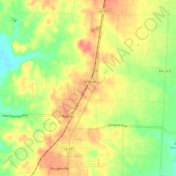
Name: Aubrey topographic map, elevation, terrain.
Location: Aubrey, Denton County, Texas, États-Unis d'Amérique (33.28671 -97.02849 33.34634 -96.93673)
Average elevation: 197 m
Minimum elevation: 167 m
Maximum elevation: 223 m
Other topographic maps
Click on a map to view its topography, its elevation and its terrain.
Lewisville
États-Unis d'Amérique > Texas > Denton County
Lewisville, Denton County, Texas, États-Unis d'Amérique
Average elevation: 160 m
Lewisville
États-Unis d'Amérique > Texas > Denton County > Lewisville
Lewisville, Denton County, Texas, 75067, États-Unis d'Amérique
Average elevation: 174 m