
Whitwell topographic map
Click on the map to display elevation.
About this map
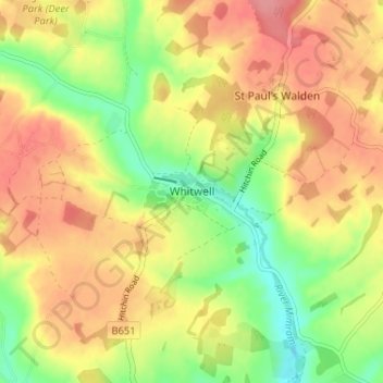
Name: Whitwell topographic map, elevation, terrain.
Average elevation: 122 m
Minimum elevation: 79 m
Maximum elevation: 158 m
Hertfordshire trails, hiking, mountain biking, running and outdoor activities
Other topographic maps
Click on a map to view its topography, its elevation and its terrain.
Newnham
United Kingdom > England > Hertfordshire > North Hertfordshire > Baldock
Average elevation: 69 m
Windmill Hill
United Kingdom > England > Hertfordshire > North Hertfordshire > Hitchin
Average elevation: 74 m
Knebworth Country Park
United Kingdom > England > Hertfordshire > North Hertfordshire > Knebworth
Average elevation: 116 m
St Paul's Walden
United Kingdom > England > Hertfordshire > North Hertfordshire
Average elevation: 121 m
Ickleford
United Kingdom > England > Hertfordshire > North Hertfordshire > Hitchin
Average elevation: 58 m
Ivel Springs Local Nature Reserve
United Kingdom > England > Hertfordshire > North Hertfordshire > Baldock
Average elevation: 72 m
Long Pond
United Kingdom > England > Hertfordshire > North Hertfordshire > Offley > Offley Hoo
Average elevation: 142 m
Knebworth Country Park
United Kingdom > England > Hertfordshire > North Hertfordshire > Knebworth
Average elevation: 116 m