
Arts Spring topographic map
Interactive map
Click on the map to display elevation.
About this map
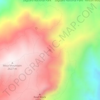
Name: Arts Spring topographic map, elevation, terrain.
Location: Arts Spring, Trail, Pima County, Arizona, USA (32.22308 -110.53151 32.22318 -110.53141)
Average elevation: 2,312 m
Minimum elevation: 1,859 m
Maximum elevation: 2,635 m
Other topographic maps
Click on a map to view its topography, its elevation and its terrain.
Mogollon Rim
Mogollon Rim, Rim Road, Coconino County, Arizona, USA
Average elevation: 2,108 m
Tonto National Forest
USA > Arizona > Roosevelt Lake Gardens East
Tonto National Forest, NF-424, Roosevelt Lake Gardens East, Gila County, Arizona, 85553, USA
Average elevation: 1,078 m
Cataract Lake
Cataract Lake, Cataract Road, Williams, Coconino County, Arizona, 86046, USA
Average elevation: 2,096 m
Superstition Mountains
Superstition Mountains, Pinal County, Arizona, USA
Average elevation: 1,125 m
Organ Pipe Cactus National Monument
Organ Pipe Cactus National Monument, Dripping Springs Trail, Pima County, Arizona, USA
Average elevation: 494 m
Sevenmile Mountains
Sevenmile Mountains, Gila County, Arizona, USA
Average elevation: 1,511 m