
Regniowez topographic map
Interactive map
Click on the map to display elevation.
About this map
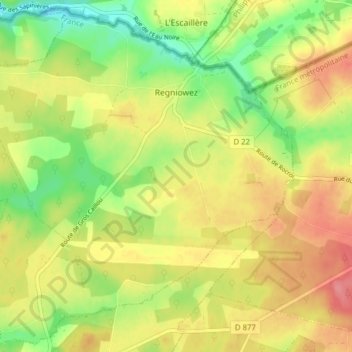
Name: Regniowez topographic map, elevation, terrain.
Average elevation: 343 m
Minimum elevation: 304 m
Maximum elevation: 379 m
Other topographic maps
Click on a map to view its topography, its elevation and its terrain.
Wadelincourt
Wadelincourt, Sedan, Ardennes, Grand Est, France métropolitaine, 08200, France
Average elevation: 179 m
Le Cheval Blanc
France > Grand Est > Ardennes > Rocroi
Le Cheval Blanc, Rocroi, Charleville-Mézières, Ardennes, Grand Est, France métropolitaine, 08230, France
Average elevation: 364 m
Les Hautes-Rivières
Les Hautes-Rivières, Charleville-Mézières, Ardennes, Grand Est, France métropolitaine, 08800, France
Average elevation: 337 m