Geolocate

Tripoli topographic map

Interactive map

Click on the map to display elevation.

About this map

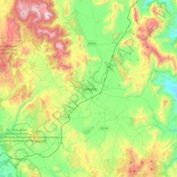
Name: Tripoli topographic map, elevation, terrain.

Location: Tripoli, Municipal Unit of Tripoli, Municipality of Tripoli, Arcadia Regional Unit, Peloponnese Region, Peloponnese, Western Greece and the Ionian, 221 00, Greece (37.35029 22.21242 37.67029 22.53242)

Average elevation: 873 m

Minimum elevation: 274 m

Maximum elevation: 1,966 m

The city of Tripolis has a hot-summer Mediterranean climate (Köppen: Csa). Ιt is located in the center of the Peloponnese, at the western border of a large basin (a polje at about 650 m in altitude, a length of ca. 30 km and a width between 12,5 and 2,5 km). The city is today the capital of the regional unit Arcadia (residents, city alone, ca. 30 000, district with hinterland ca. 47500, 2011 Greek census). At its west the city borders the thickly wooded mountain-area “Mainalo”. The Tripoli Basin has gradually been rainwater regulated (mainly after 1945 ) and turned into farmland. In the southwest floods, which appear in the basin occasionally after rainy winters, as in 2003, formed the temporary Lake Taka. This lake was regulated by a new pond, to retain water for irrigation.

Wikipedia (CC-BY-SA 3.0)

Other topographic maps

Click on a map to view its topography, its elevation and its terrain.

Nestani

Greece > Peloponnese, Western Greece and the Ionian > Arcadia Regional Unit > Municipal Unit of Mantineia

Nestani, Municipal Unit of Mantineia, Municipality of Tripoli, Arcadia Regional Unit, Peloponnese Region, Peloponnese, Western Greece and the Ionian, 220 05, Greece

Average elevation: 827 m

Tower of Nestani

Greece > Peloponnese, Western Greece and the Ionian > Arcadia Regional Unit > Municipal Unit of Mantineia

Tower of Nestani, Corinth - Tripoli - Kalamata, κ. Σάγκα, Community of Nestani, Municipal Unit of Mantineia, Municipality of Tripoli, Arcadia Regional Unit, Peloponnese Region, Peloponnese, Western Greece and the Ionian, 220 05, Greece

Average elevation: 753 m

Kastri

Greece > Peloponnese, Western Greece and the Ionian > Arcadia Regional Unit

Kastri, Municipality of North Kynouria, Arcadia Regional Unit, Peloponnese Region, Peloponnese, Western Greece and the Ionian, 220 13, Greece

Average elevation: 944 m

Agios Andreas

Greece > Peloponnese, Western Greece and the Ionian > Arcadia Regional Unit

Agios Andreas, Municipality of North Kynouria, Arcadia Regional Unit, Peloponnese Region, Peloponnese, Western Greece and the Ionian, 220 06, Greece

Average elevation: 164 m

Akra

Greece > Peloponnese, Western Greece and the Ionian > Arcadia Regional Unit > Municipal Unit of Tegea

Akra, Stadio Community, Municipal Unit of Tegea, Municipality of Tripoli, Arcadia Regional Unit, Peloponnese Region, Peloponnese, Western Greece and the Ionian, 220 12, Greece

Average elevation: 666 m

Astros Beach

Greece > Peloponnese, Western Greece and the Ionian > Arcadia Regional Unit

Astros Beach, Municipality of North Kynouria, Arcadia Regional Unit, Peloponnese Region, Peloponnese, Western Greece and the Ionian, 220 19, Greece

Average elevation: 3 m

Lousios

Greece > Peloponnese, Western Greece and the Ionian > Arcadia Regional Unit > Municipal Unit of Gortyna

Lousios, κ. Ατσιχόλου, Municipal Unit of Gortyna, Municipality of Megalopoli, Arcadia Regional Unit, Peloponnese Region, Peloponnese, Western Greece and the Ionian, 220 24, Greece

Average elevation: 440 m

Megalopoli

Greece > Peloponnese, Western Greece and the Ionian > Arcadia Regional Unit > Municipal Unit of Megalopoli

Megalopoli, Municipal Unit of Megalopoli, Municipality of Megalopoli, Arcadia Regional Unit, Peloponnese Region, Peloponnese, Western Greece and the Ionian, 222 00, Greece

Average elevation: 434 m

Chirades

Greece > Peloponnese, Western Greece and the Ionian > Arcadia Regional Unit > Municipal Unit of Megalopoli

Chirades, Municipal Unit of Megalopoli, Municipality of Megalopoli, Arcadia Regional Unit, Peloponnese Region, Peloponnese, Western Greece and the Ionian, 222 00, Greece

Average elevation: 708 m