
Make a donation
Gear up for your next adventure:
As an Amazon Associate, this site earns from qualifying purchases at no extra cost to you.
Paradise topographic map
Click on the map to display elevation.
Make a donation
Gear up for your next adventure:
As an Amazon Associate, this site earns from qualifying purchases at no extra cost to you.
Paradise
Paradise is located at 47°23′17″N 114°48′3″W / 47.38806°N 114.80083°W / 47.38806; -114.80083 (47.388097, -114.800723), elevation 2,250 feet (690 m). It is at the confluence of the Flathead River and Clark Fork River. Nearby Patrick's Knob reaches 6,775 feet (2,065 m).
Make a donation
Gear up for your next adventure:
As an Amazon Associate, this site earns from qualifying purchases at no extra cost to you.
About this map
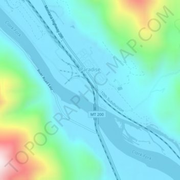
Name: Paradise topographic map, elevation, terrain.
Location: Paradise, Sanders County, Montana, United States (47.38006 -114.80703 47.39195 -114.78914)
Average elevation: 881 m
Minimum elevation: 749 m
Maximum elevation: 1,467 m
Make a donation
Gear up for your next adventure:
As an Amazon Associate, this site earns from qualifying purchases at no extra cost to you.