
Tuckasegee topographic map
Click on the map to display elevation.
About this map
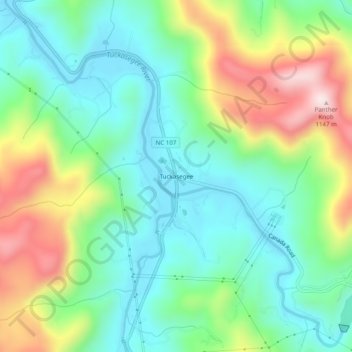
Name: Tuckasegee topographic map, elevation, terrain.
Average elevation: 803 m
Minimum elevation: 645 m
Maximum elevation: 1,130 m
Other topographic maps
Click on a map to view its topography, its elevation and its terrain.
Cashiers
United States > North Carolina > Jackson County > Cashiers
Cashiers lies in southern Jackson County on the elevated Highlands-Cashiers Plateau, a highland setting within the southern Blue Ridge Mountains, with the village center standing at about 3,500 feet (1,067 m) above sea level. Its topography is defined by a relatively open mountain basin surrounded by higher…
Average elevation: 1,085 m
Wolf Creek Lake
United States > North Carolina > Jackson County > Wolf Mountain
Average elevation: 1,021 m
Eastern Band of Cherokee Indians
United States > North Carolina > Jackson County > Wolftown Community
Average elevation: 980 m
Bear Creek Lake
United States > North Carolina > Jackson County > Island Ford
Average elevation: 936 m
Cashiers
United States > North Carolina > Jackson County > Cashiers
Cashiers lies in southern Jackson County on the elevated Highlands-Cashiers Plateau, a highland setting within the southern Blue Ridge Mountains, with the village center standing at about 3,500 feet (1,067 m) above sea level. Its topography is defined by a relatively open mountain basin surrounded by higher…
Average elevation: 1,085 m
Eastern Band of Cherokee Indians
United States > North Carolina > Jackson County > Wolftown Community
Average elevation: 980 m