
Sylva topographic map
Click on the map to display elevation.
About this map
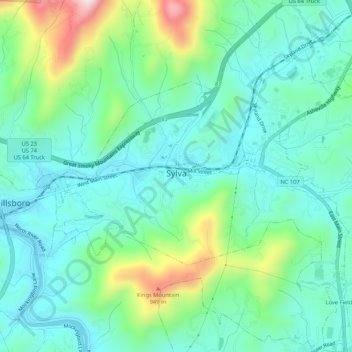
Name: Sylva topographic map, elevation, terrain.
Location: Sylva, Jackson County, North Carolina, 28779, United States (35.35178 -83.24307 35.39490 -83.19555)
Average elevation: 708 m
Minimum elevation: 597 m
Maximum elevation: 1,043 m
Other topographic maps
Click on a map to view its topography, its elevation and its terrain.
Wolf Creek Lake
United States > North Carolina > Jackson County > Wolf Mountain
Average elevation: 1,021 m