
Make a donation
Gear up for your next adventure:
As an Amazon Associate, this site earns from qualifying purchases at no extra cost to you.
Port Royal topographic map
Click on the map to display elevation.
Make a donation
Gear up for your next adventure:
As an Amazon Associate, this site earns from qualifying purchases at no extra cost to you.
About this map
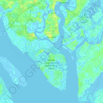
Name: Port Royal topographic map, elevation, terrain.
Location: Port Royal, Beaufort County, South Carolina, United States (32.29880 -80.84387 32.41520 -80.65823)
Average elevation: 2 m
Minimum elevation: -4 m
Maximum elevation: 17 m
Make a donation
Gear up for your next adventure:
As an Amazon Associate, this site earns from qualifying purchases at no extra cost to you.
Other topographic maps
Click on a map to view its topography, its elevation and its terrain.
Royal Pines Country Club Estates
United States > South Carolina > Beaufort County
Average elevation: 7 m
Hilton Head Plantation
United States > South Carolina > Beaufort County > Hilton Head Island
Average elevation: 6 m
Palmetto Dunes
United States > South Carolina > Beaufort County > Hilton Head Island
Average elevation: 3 m
Make a donation
Gear up for your next adventure:
As an Amazon Associate, this site earns from qualifying purchases at no extra cost to you.
Make a donation
Gear up for your next adventure:
As an Amazon Associate, this site earns from qualifying purchases at no extra cost to you.
Palmetto Dunes
United States > South Carolina > Beaufort County > Hilton Head Island
Average elevation: 3 m
Hilton Head Island
United States > South Carolina > Beaufort County > Hilton Head Island
Average elevation: 2 m
Port Royal
United States > South Carolina > Beaufort County > Hilton Head Island
Average elevation: 3 m
Make a donation
Gear up for your next adventure:
As an Amazon Associate, this site earns from qualifying purchases at no extra cost to you.
Sea Pines
United States > South Carolina > Beaufort County > Hilton Head Island
Average elevation: 4 m
Indigo Run
United States > South Carolina > Beaufort County > Hilton Head Island
Average elevation: 5 m
Make a donation
Gear up for your next adventure:
As an Amazon Associate, this site earns from qualifying purchases at no extra cost to you.
Hilton Head Plantation
United States > South Carolina > Beaufort County > Hilton Head Island > Hilton Head Plantation
Average elevation: 6 m
Make a donation
Gear up for your next adventure:
As an Amazon Associate, this site earns from qualifying purchases at no extra cost to you.
Morgan River Estates
United States > South Carolina > Beaufort County > Morgan River Estates
Average elevation: 4 m