
Royston topographic map
Interactive map
Click on the map to display elevation.
About this map
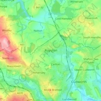
Name: Royston topographic map, elevation, terrain.
Average elevation: 74 m
Minimum elevation: 31 m
Maximum elevation: 173 m
Royston lies on the Barnsley Canal, and on the intersection of the B6132 and B6428 roads, due north of Monk Bretton at an elevation of around 246 feet (75 m) above sea level. The Trans Pennine Trail runs through Royston along the canal bank. The parish is part of the diocese of Leeds.
Other topographic maps
Click on a map to view its topography, its elevation and its terrain.
Royston
United Kingdom > England > North Hertfordshire > Royston
Royston, Hertfordshire, East of England, England, SG8 9AQ, United Kingdom
Average elevation: 78 m