
Thank you for supporting this site ❤️
Make a donation
Make a donation
Gear up for your next adventure:
As an Amazon Associate, this site earns from qualifying purchases at no extra cost to you.
Yamunanagar topographic map
Click on the map to display elevation.
Thank you for supporting this site ❤️
Make a donation
Make a donation
Gear up for your next adventure:
As an Amazon Associate, this site earns from qualifying purchases at no extra cost to you.
About this map
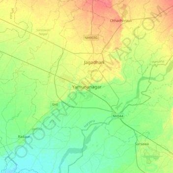
Name: Yamunanagar topographic map, elevation, terrain.
Location: Yamunanagar, Jagadhri, Yamunanagar, Haryana, 135001, India (29.96313 77.12633 30.28313 77.44633)
Average elevation: 277 m
Minimum elevation: 259 m
Maximum elevation: 306 m
Thank you for supporting this site ❤️
Make a donation
Make a donation
Gear up for your next adventure:
As an Amazon Associate, this site earns from qualifying purchases at no extra cost to you.