
Neu Wulmstorf topographic map
Interactive map
Click on the map to display elevation.
Neu Wulmstorf
Further up, the villages Wulmstorf, Daerstorf, Schwiederstorf, Rade are marking the highest elevations of Neu Wulmstorf on the western outskirts of the Harburg Hills.
About this map
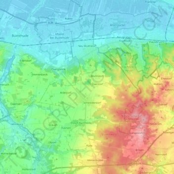
Name: Neu Wulmstorf topographic map, elevation, terrain.
Location: Neu Wulmstorf, Harburg, Lower Saxony, 21629, Germany (53.36442 9.72640 53.50530 9.86183)
Average elevation: 44 m
Minimum elevation: -2 m
Maximum elevation: 154 m
Other topographic maps
Click on a map to view its topography, its elevation and its terrain.