
Kabwum District topographic map
Interactive map
Click on the map to display elevation.
About this map
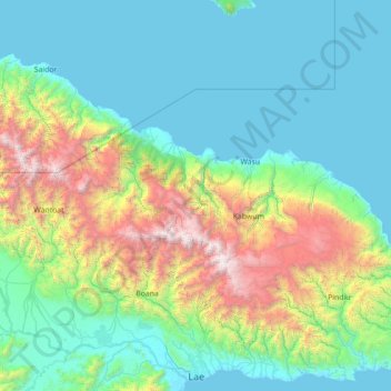
Name: Kabwum District topographic map, elevation, terrain.
Location: Kabwum District, Morobe, Momase Region, Papua New Guinea (-6.78333 146.30000 -5.38333 147.70000)
Average elevation: 757 m
Minimum elevation: 0 m
Maximum elevation: 4,073 m
Other topographic maps
Click on a map to view its topography, its elevation and its terrain.