Geolocate

Corner Brook topographic map

Click on the map to display elevation.

About this map

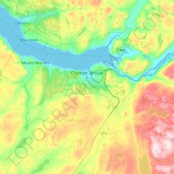
Name: Corner Brook topographic map, elevation, terrain.

Location: Corner Brook, Newfoundland, Newfoundland and Labrador, Canada (48.87659 -58.06451 48.99529 -57.74025)

Average elevation: 236 m

Minimum elevation: -1 m

Maximum elevation: 659 m

Other topographic maps

Click on a map to view its topography, its elevation and its terrain.

Spot Pond

Canada > Newfoundland and Labrador

Average elevation: 118 m

LaScie

Canada > Newfoundland and Labrador

Average elevation: 98 m

The Peak

Canada > Newfoundland and Labrador

Average elevation: 67 m

Roundabout

Canada > Newfoundland and Labrador

Average elevation: 65 m

The Cabox

Canada > Newfoundland and Labrador

Average elevation: 698 m

White Horse

Canada > Newfoundland and Labrador

Average elevation: 99 m

Botwood

Canada > Newfoundland and Labrador > Botwood

Average elevation: 17 m

Mount Caubvick

Canada > Newfoundland and Labrador

Average elevation: 1,272 m

Gear up for your next adventure:

🧥Waterproof Hiking Jackets - Rain protection for walking in all weather conditions
🎒Hiking Daypacks (20L) - Compact backpacks for day trips and technical mountain ascents
🕶️Glacier Goggles - Maximum protection for high-altitude snow topography
🔦Waterproof LED Headlamps - Hands-free lighting for evening treks and emergency navigation
🦯Walking Poles - Supportive poles for long-distance walking

As an Amazon Associate, this site earns from qualifying purchases at no extra cost to you.