
Make a donation
Gear up for your next adventure:
As an Amazon Associate, this site earns from qualifying purchases at no extra cost to you.
Emmetten topographic map
Click on the map to display elevation.
Make a donation
Gear up for your next adventure:
As an Amazon Associate, this site earns from qualifying purchases at no extra cost to you.
About this map
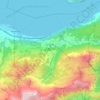
Name: Emmetten topographic map, elevation, terrain.
Location: Emmetten, Nidwalden, 6376, Switzerland (46.91443 8.48429 46.99016 8.57495)
Average elevation: 1,009 m
Minimum elevation: 425 m
Maximum elevation: 2,241 m
Make a donation
Gear up for your next adventure:
As an Amazon Associate, this site earns from qualifying purchases at no extra cost to you.
Other topographic maps
Click on a map to view its topography, its elevation and its terrain.
ewl Ausgleichsbecken Untertrübsee
Switzerland > Nidwalden > Wolfenschiessen
Average elevation: 1,458 m
Bürgenstock
Switzerland > Nidwalden > Ennetbürgen
On the Dufourkarte (Dufour Map), the topographic map of Switzerland from 1844 to 1864, the mountain ridge as a whole had no name. The highest crest was referred to as Hametschwand.
Average elevation: 641 m
Make a donation
Gear up for your next adventure:
As an Amazon Associate, this site earns from qualifying purchases at no extra cost to you.