
Make a donation
Gear up for your next adventure:
As an Amazon Associate, this site earns from qualifying purchases at no extra cost to you.
Roccasecca topographic map
Click on the map to display elevation.
Make a donation
Gear up for your next adventure:
As an Amazon Associate, this site earns from qualifying purchases at no extra cost to you.
Roccasecca
The history of Roccasecca is tightly bound to its strategic position, a "dry rocca" at the entrance to two narrow defiles that give access to the Valle di Comino below the slopes of Monte Asprano, whose elevation at 553 metres (1,814 ft) provides a natural position to control the wide Valle del Liri. Remains of archaic perimeter walling attest to an early fortified presence around the site. Roccasecca served as a way station for ancient Roman legions and invading armies crossing the River Melfa, spanned by three ancient bridges there, remains of which still exist. However, the Medieval commune truly began in the early Middle Ages.
Make a donation
Gear up for your next adventure:
As an Amazon Associate, this site earns from qualifying purchases at no extra cost to you.
About this map
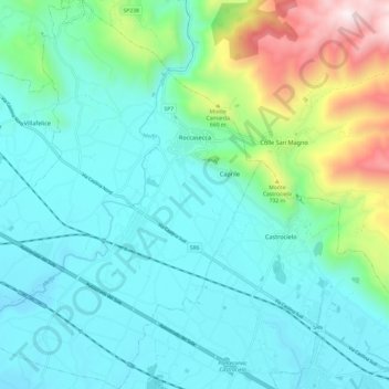
Name: Roccasecca topographic map, elevation, terrain.
Location: Roccasecca, Frosinone, Lazio, 03038, Italy (41.49380 13.58465 41.58416 13.68777)
Average elevation: 327 m
Minimum elevation: 72 m
Maximum elevation: 1,306 m
Make a donation
Gear up for your next adventure:
As an Amazon Associate, this site earns from qualifying purchases at no extra cost to you.
Other topographic maps
Click on a map to view its topography, its elevation and its terrain.
Make a donation
Gear up for your next adventure:
As an Amazon Associate, this site earns from qualifying purchases at no extra cost to you.