
Make a donation
Gear up for your next adventure:
As an Amazon Associate, this site earns from qualifying purchases at no extra cost to you.
Vernon topographic map
Click on the map to display elevation.
Make a donation
Gear up for your next adventure:
As an Amazon Associate, this site earns from qualifying purchases at no extra cost to you.
About this map
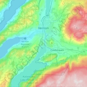
Name: Vernon topographic map, elevation, terrain.
Average elevation: 676 m
Minimum elevation: 338 m
Maximum elevation: 1,486 m
Make a donation
Gear up for your next adventure:
As an Amazon Associate, this site earns from qualifying purchases at no extra cost to you.
Other topographic maps
Click on a map to view its topography, its elevation and its terrain.
Silver Star Mountain Resort
Canada > British Columbia > Regional District of North Okanagan > Area C (Silver Star)
Average elevation: 1,584 m
Big Peters Lake
Canada > British Columbia > Regional District of North Okanagan > Area E (Cherryville/East Creighton)
Average elevation: 1,850 m
Lavington
Canada > British Columbia > Regional District of North Okanagan > Coldstream
Average elevation: 648 m
Enderby Cliffs
Canada > British Columbia > Regional District of North Okanagan > Area F (Grindrod/Ashton Creek/Mabel Lake)
Average elevation: 911 m
Make a donation
Gear up for your next adventure:
As an Amazon Associate, this site earns from qualifying purchases at no extra cost to you.
Curtis Lake
Canada > British Columbia > Regional District of North Okanagan > Area D (Trinity/West Creighton)
Average elevation: 1,328 m
Vernon
Canada > British Columbia > Regional District of North Okanagan > Vernon
Average elevation: 852 m
Thompson Plateau
Canada > British Columbia > Regional District of North Okanagan > Area B (Westside/Swan Lake/Kalamalka Lake)
Average elevation: 1,264 m
Make a donation
Gear up for your next adventure:
As an Amazon Associate, this site earns from qualifying purchases at no extra cost to you.
Cooke Creek
Canada > British Columbia > Regional District of North Okanagan > Area F (Grindrod/Ashton Creek/Mabel Lake)
Average elevation: 838 m
Loon Lake
Canada > British Columbia > Regional District of North Okanagan > Area D (Trinity/West Creighton)
Average elevation: 1,360 m
Cherryville
Canada > British Columbia > Regional District of North Okanagan > Area E (Cherryville/East Creighton)
Average elevation: 643 m
Echo Lake Provincial Park
Canada > British Columbia > Regional District of North Okanagan > Area D (Trinity/West Creighton)
Average elevation: 1,119 m
Make a donation
Gear up for your next adventure:
As an Amazon Associate, this site earns from qualifying purchases at no extra cost to you.
Monashee Mountains
Canada > British Columbia > Regional District of North Okanagan > Area F (Grindrod/Ashton Creek/Mabel Lake)
Average elevation: 1,685 m
Silver Star Mountain
Canada > British Columbia > Regional District of North Okanagan > Area C (Silver Star)
Average elevation: 1,706 m
Grindrod
Canada > British Columbia > Regional District of North Okanagan > Area F (Grindrod/Ashton Creek/Mabel Lake)
Average elevation: 406 m
Ellison Elemtary Park
Canada > British Columbia > Regional District of North Okanagan > Vernon
Average elevation: 399 m
Make a donation
Gear up for your next adventure:
As an Amazon Associate, this site earns from qualifying purchases at no extra cost to you.
Armstrong
Canada > British Columbia > Regional District of North Okanagan > Armstrong > Armstrong
Average elevation: 494 m
Kalamalka
Canada > British Columbia > Regional District of North Okanagan > Area B (Westside/Swan Lake/Kalamalka Lake)
Average elevation: 454 m
Cherryville
Canada > British Columbia > Regional District of North Okanagan > Area E (Cherryville/East Creighton)
Average elevation: 643 m