Geolocate

Town of Plattsburgh topographic map

Interactive map

Click on the map to display elevation.

About this map

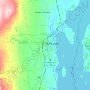
Name: Town of Plattsburgh topographic map, elevation, terrain.

Location: Town of Plattsburgh, Clinton County, New York, 12902, United States (44.62229 -73.67210 44.75617 -73.35396)

Average elevation: 106 m

Minimum elevation: 28 m

Maximum elevation: 457 m

Other topographic maps

Click on a map to view its topography, its elevation and its terrain.

Town of Champlain

United States > New York > Clinton County

Town of Champlain, Clinton County, New York, United States

Average elevation: 55 m

City of Plattsburgh

United States > New York > Clinton County

City of Plattsburgh, Clinton County, New York, United States

Average elevation: 50 m

Catfish Bay

United States > New York > Clinton County > Champlain

Catfish Bay, Champlain, Clinton County, New York, 12979, United States

Average elevation: 31 m

Dannemora

United States > New York > Clinton County > Dannemora

Dannemora, Clinton County, New York, 12929, United States

Average elevation: 445 m