
Bayview topographic map
Click on the map to display elevation.
Bayview
Bayview is an unincorporated community in the northwest United States, located in Kootenai County, Idaho, north of Coeur d'Alene. On the southwest shore of Lake Pend Oreille, Bayview is seven miles (11 km) east-northeast of Athol. The community is served by State Highway 54 and a post office with ZIP code 83803; its approximate elevation is 2,100 feet (640 m) above sea level. Nearby is Farragut State Park, formerly the Farragut Naval Training Station, a major training facility during World War II.
About this map
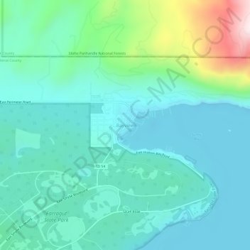
Name: Bayview topographic map, elevation, terrain.
Location: Bayview, Kootenai County, Idaho, United States (47.96033 -116.58043 48.00033 -116.54043)
Average elevation: 733 m
Minimum elevation: 616 m
Maximum elevation: 1,195 m
Other topographic maps
Click on a map to view its topography, its elevation and its terrain.
Coeur d'Alene
United States > Idaho > Kootenai County
The city is located on the north shore of Lake Coeur d'Alene, near the outlet of the Spokane River, and is in the Northern Rockies ecoregion. Lake Coeur d'Alene is a natural dam-controlled lake that is 25 miles (40 km) long and 1 mile (1.6 km) to 3 miles (4.8 km) wide and fed by the Coeur d'Alene and Saint Joe…
Average elevation: 719 m
Post Falls
United States > Idaho > Kootenai County
Post Falls features a varied and distinctive topography characterized by its placement on the Rathdrum Prairie, which lies at an elevation of approximately 2,182 feet (665 meters) above sea level. This prairie is surrounded by rolling hills and rugged terrain that gradually rise towards the nearby Rocky…
Average elevation: 710 m
Rathdrum
United States > Idaho > Kootenai County
Rathdrum is located on the Rathdrum Prairie at 47°48′30″N 116°53′33″W / 47.80833°N 116.89250°W / 47.80833; -116.89250 (47.808457, -116.892415), at an elevation of 2,211 feet (674 m) above sea level.
Average elevation: 701 m
Spirit Lake
United States > Idaho > Kootenai County
Spirit Lake is located at 47°58′00″N 116°51′59″W / 47.966592°N 116.866383°W / 47.966592; -116.866383, at an elevation of 2,569 feet (783 m) above sea level.
Average elevation: 780 m
Hayden
United States > Idaho > Kootenai County
According to the United States Census Bureau, the city has a total area of 9.61 square miles (24.89 km2), of which 9.60 square miles (24.86 km2) is land and 0.01 square miles (0.03 km2) is water. It lies at the southwestern end of Hayden Lake, and the elevation of the city is 2,287 feet (697 m) above sea level.
Average elevation: 709 m
Athol
United States > Idaho > Kootenai County
Athol is located at 47°56′46″N 116°42′26″W / 47.94611°N 116.70722°W / 47.94611; -116.70722 (47.946024, -116.707349), at an elevation of 2,392 feet (729 m) above sea level.
Average elevation: 733 m
Coeur d'Alene
United States > Idaho > Kootenai County
The city is located on the north shore of Lake Coeur d'Alene, near the outlet of the Spokane River, and is in the Northern Rockies ecoregion. Lake Coeur d'Alene is a natural dam-controlled lake that is 25 miles (40 km) long and 1 mile (1.6 km) to 3 miles (4.8 km) wide and fed by the Coeur d'Alene and Saint Joe…
Average elevation: 719 m
Athol
United States > Idaho > Kootenai County
Athol is located at 47°56′46″N 116°42′26″W / 47.94611°N 116.70722°W / 47.94611; -116.70722 (47.946024, -116.707349), at an elevation of 2,392 feet (729 m) above sea level.
Average elevation: 733 m
Post Falls
United States > Idaho > Kootenai County
Post Falls is located on the Rathdrum Prairie, along the Washington–Idaho border. It is bounded by Coeur d’Alene to the east, Stateline and the state of Washington to the west, and the Spokane River to the south. Post Falls is 20 miles (32 km) east of Spokane and approximately 100 miles (160 km) south of…
Average elevation: 710 m
Coeur d'Alene
United States > Idaho > Kootenai County
The city is located on the north shore of Lake Coeur d'Alene, near the outlet of the Spokane River, and is in the Northern Rockies ecoregion. Lake Coeur d'Alene is a natural dam-controlled lake that is 25 miles (40 km) long and 1 mile (1.6 km) to 3 miles (4.8 km) wide and fed by the Coeur d'Alene and Saint Joe…
Average elevation: 719 m
Hayden
United States > Idaho > Kootenai County
According to the United States Census Bureau, the city has a total area of 9.61 square miles (24.89 km2), of which 9.60 square miles (24.86 km2) is land and 0.01 square miles (0.03 km2) is water. It lies at the southwestern end of Hayden Lake, and the elevation of the city is 2,287 feet (697 m) above sea level.
Average elevation: 709 m
Post Falls
United States > Idaho > Kootenai County
Post Falls is located on the Rathdrum Prairie, along the Washington–Idaho border. It is bounded by Coeur d’Alene to the east, Stateline and the state of Washington to the west, and the Spokane River to the south. Post Falls is 20 miles (32 km) east of Spokane and approximately 100 miles (160 km) south of…
Average elevation: 710 m
Coeur d'Alene
United States > Idaho > Kootenai County
The city is located on the north shore of Lake Coeur d'Alene, near the outlet of the Spokane River, and is in the Northern Rockies ecoregion. Lake Coeur d'Alene is a natural dam-controlled lake that is 25 miles (40 km) long and 1 mile (1.6 km) to 3 miles (4.8 km) wide and fed by the Coeur d'Alene and Saint Joe…
Average elevation: 719 m