
Make a donation
Gear up for your next adventure:
As an Amazon Associate, this site earns from qualifying purchases at no extra cost to you.
Packsaddle Lake topographic map
Click on the map to display elevation.
Make a donation
Gear up for your next adventure:
As an Amazon Associate, this site earns from qualifying purchases at no extra cost to you.
About this map
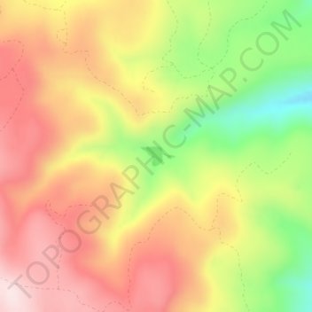
Name: Packsaddle Lake topographic map, elevation, terrain.
Location: Packsaddle Lake, Teton County, Idaho, United States (43.76935 -111.34224 43.77105 -111.33954)
Average elevation: 2,331 m
Minimum elevation: 2,106 m
Maximum elevation: 2,503 m
Make a donation
Gear up for your next adventure:
As an Amazon Associate, this site earns from qualifying purchases at no extra cost to you.
Other topographic maps
Click on a map to view its topography, its elevation and its terrain.
Victor
United States > Idaho > Teton County
Victor is located at 43°36′11″N 111°6′44″W / 43.60306°N 111.11222°W / 43.60306; -111.11222 (43.602945, -111.112343), at an elevation of 6,214 feet (1,894 m) above sea level.
Average elevation: 1,895 m
Make a donation
Gear up for your next adventure:
As an Amazon Associate, this site earns from qualifying purchases at no extra cost to you.