
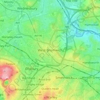
West Bromwich topographic map
Interactive map
Click on the map to display elevation.
About this map
Name: West Bromwich topographic map, elevation, terrain.
Average elevation: 149 m
Minimum elevation: 98 m
Maximum elevation: 270 m
The town's football club is West Bromwich Albion. The club was founded in 1878 and in 1888 it became one of the 12 founder members of the Football League. It won the league championship in 1920 and has won the FA Cup five times, most recently in 1968, and won the League Cup in 1966. Albion were based in and around the centre of West Bromwich during their formative years, but moved further out of the town in 1900 when they switched to their current ground, The Hawthorns. All traces of the original structures are long gone; the present structures were added to the stadium in 1979, 1994 and most recently 2001. At an altitude of 551 feet, The Hawthorns is the highest football ground (above sea level) in the country.
Other topographic maps
Click on a map to view its topography, its elevation and its terrain.
Tividale
United Kingdom > England > Sandwell
Tividale, Sandwell, West Midlands Combined Authority, England, B69 1RQ, United Kingdom
Average elevation: 167 m
Rowley Village
United Kingdom > England > Sandwell
Rowley Village, Sandwell, West Midlands Combined Authority, England, B65 9EW, United Kingdom
Average elevation: 170 m
Titford
United Kingdom > England > Sandwell > Causeway Green
Titford, Causeway Green, Sandwell, West Midlands Combined Authority, England, B69 4QF, United Kingdom
Average elevation: 181 m
Wednesbury
United Kingdom > England > Sandwell
Wednesbury, Sandwell, West Midlands Combined Authority, England, WS10 7BF, United Kingdom
Average elevation: 137 m
Stone Cross
United Kingdom > England > Sandwell > Wednesbury
Stone Cross, Wednesbury, Sandwell, West Midlands Combined Authority, England, B71 3LB, United Kingdom
Average elevation: 128 m
Rowley Hills
United Kingdom > England > Sandwell > Rounds Green > Turner's Portway
Rowley Hills, Ivy House Road, Lion Farm Estate, Turner's Portway, Rounds Green, Sandwell, West Midlands Combined Authority, England, B69 1HG, United Kingdom
Average elevation: 182 m
Smethwick
United Kingdom > England > Sandwell
Smethwick, Sandwell, West Midlands Combined Authority, England, B67 7QX, United Kingdom
Average elevation: 156 m
Tipton
United Kingdom > England > Sandwell
Tipton, Sandwell, West Midlands Combined Authority, England, DY4 8ES, United Kingdom
Average elevation: 159 m
Ryders Green
United Kingdom > England > Sandwell > Oldbury
Ryders Green, Oldbury, Sandwell, West Midlands Combined Authority, England, B70 0BW, United Kingdom
Average elevation: 143 m
Oldbury
United Kingdom > England > Sandwell
Oldbury, Sandwell, West Midlands Combined Authority, England, B69 2AJ, United Kingdom
Average elevation: 161 m
Merrivale
United Kingdom > England > Sandwell
Merrivale, Sandwell, West Midlands Combined Authority, England, B68 9LU, United Kingdom
Average elevation: 171 m
Jarvis
United Kingdom > England > Sandwell > Causeway Green > Jarvis
Jarvis, Causeway Green, Sandwell, West Midlands Combined Authority, West Midlands, England, B69 4XA, United Kingdom
Average elevation: 179 m
Quinton
United Kingdom > England > Sandwell > Bearwood
Quinton, Bearwood, Sandwell, West Midlands Combined Authority, West Midlands, England, United Kingdom
Average elevation: 191 m
Moat Farm
United Kingdom > England > Sandwell > Queen's Head
Moat Farm, Queen's Head, Sandwell, West Midlands Combined Authority, England, B68 9TW, United Kingdom
Average elevation: 180 m
Hilltop
United Kingdom > England > Sandwell > Bleakhouse > Hilltop
Hilltop, Bleakhouse, Sandwell, West Midlands Combined Authority, West Midlands, England, B68 9DZ, United Kingdom
Average elevation: 184 m
Rowley Regis
United Kingdom > England > Sandwell
Rowley Regis, Sandwell, West Midlands Combined Authority, England, DY2 9LT, United Kingdom
Average elevation: 155 m