
Hamra topographic map
Interactive map
Click on the map to display elevation.
About this map
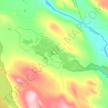
Name: Hamra topographic map, elevation, terrain.
Location: Hamra, Ljusdals kommun, Comté de Gävleborg, Suède (61.73231 14.72939 61.78063 14.93119)
Average elevation: 437 m
Minimum elevation: 330 m
Maximum elevation: 605 m
Other topographic maps
Click on a map to view its topography, its elevation and its terrain.
Nore
Nore, Ljusdals kommun, Comté de Gävleborg, 827 30, Suède
Average elevation: 142 m
Tärnön
Suède > Comté de Gävleborg > Agö hamn
Tärnön, Agö hamn, Hudiksvalls kommun, Comté de Gävleborg, Suède
Average elevation: 5 m
Gävle
Gävle, Gävle kommun, Comté de Gävleborg, Suède
Average elevation: 27 m
Hofors kommun
Hofors kommun, Comté de Gävleborg, Suède
Average elevation: 147 m
Söderhamn
Söderhamn, Söderhamns kommun, Comté de Gävleborg, 826 30, Suède
Average elevation: 24 m