
Episkopi topographic map
Interactive map
Click on the map to display elevation.
Episkopi
Aitania village is located on a hill west of Episkopi village, in the inland of Hersonissos Municipality, and on the east of Karteros Potamos Valley with a northern view to the sea, at an altitude of 255 m. The population is approximately 319 inhabitants. Its churches and the landscape of the valley of Karteros Potamos make it a destination for tourists. There are traditional cafes in the cobblestoned square of the village where orange trees, mulberry, oleanders and pomegranates grow. Churches include Agios Ioannis, Genesis of Theotokou and Agia Paraskeuh, all three of them dating to the 13th century.
About this map
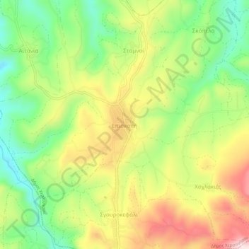
Name: Episkopi topographic map, elevation, terrain.
Average elevation: 289 m
Minimum elevation: 121 m
Maximum elevation: 491 m