
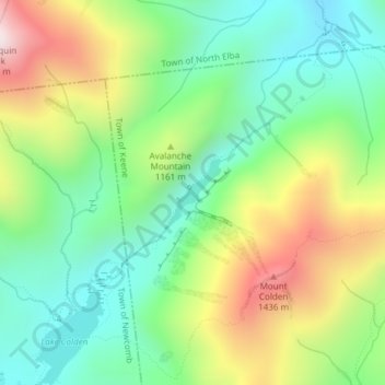
Avalanche Lake topographic map
Interactive map
Click on the map to display elevation.
About this map
Name: Avalanche Lake topographic map, elevation, terrain.
Average elevation: 1,066 m
Minimum elevation: 788 m
Maximum elevation: 1,541 m
Other topographic maps
Click on a map to view its topography, its elevation and its terrain.
Graham
USA > New York > Town of Mount Pleasant > Graham
Graham, Town of Mount Pleasant, Westchester County, New York, 10532, USA
Average elevation: 111 m
Flat Top Mountain
Flat Top Mountain, Franklin County, New York, USA
Average elevation: 568 m
Livingston Island
Livingston Island, Town of Philipstown, Putnam County, New York, 10922, USA
Average elevation: 156 m
Roosevelt Island
USA > New York > New York City
Roosevelt Island, Manhattan Community Board 8, New York County, New York City, New York, 10044, USA
Average elevation: 13 m
Falls Creek
Falls Creek, Town of Delhi, Delaware County, New York, 13753, USA
Average elevation: 515 m
Midtown South
USA > New York > New York City
Midtown South, Manhattan, Manhattan Community Board 5, New York County, New York City, New York, 10118, USA
Average elevation: 20 m
Farmingville
USA > New York > Farmingville
Farmingville, Suffolk County, New York, 11738, USA
Average elevation: 47 m