
Lajas topographic map
Interactive map
Click on the map to display elevation.
About this map
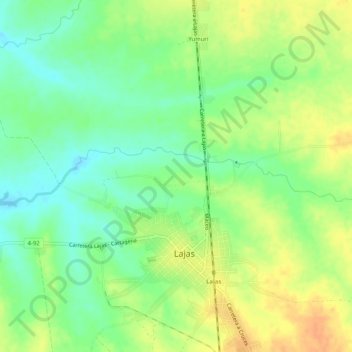
Name: Lajas topographic map, elevation, terrain.
Location: Lajas, Santa Isabel de las Lajas, Cienfuegos, Cuba (22.42209 -80.32080 22.42984 -80.26963)
Average elevation: 69 m
Minimum elevation: 51 m
Maximum elevation: 89 m
Other topographic maps
Click on a map to view its topography, its elevation and its terrain.
San Francisco
Cuba > Cienfuegos > Cumanayagua > San Francisco
San Francisco, Cumanayagua, Cienfuegos, Cuba
Average elevation: 45 m