
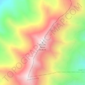
Mount Nebo topographic map
Interactive map
Click on the map to display elevation.
About this map
Name: Mount Nebo topographic map, elevation, terrain.
Location: Mount Nebo, Juab County, Utah, United States (39.82159 -111.76046 39.82169 -111.76036)
Average elevation: 3,115 m
Minimum elevation: 2,507 m
Maximum elevation: 3,622 m
Other topographic maps
Click on a map to view its topography, its elevation and its terrain.
Mona
United States > Utah > Juab County
Mount Nebo, the southernmost and highest mountain in the Wasatch Range, rises 5 miles (8 km) east of Mona to an elevation of 11,928 feet (3,636 m).
Average elevation: 1,524 m