
Blythe topographic map
Interactive map
Click on the map to display elevation.
About this map
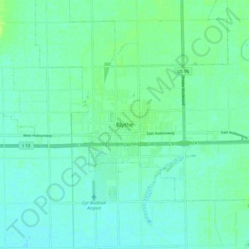
Name: Blythe topographic map, elevation, terrain.
Location: Blythe, Riverside County, California, 92226, United States (33.57348 -114.63375 33.65348 -114.55375)
Average elevation: 82 m
Minimum elevation: 77 m
Maximum elevation: 90 m
Other topographic maps
Click on a map to view its topography, its elevation and its terrain.
Colorado River
United States > California > Riverside County > Blythe
The entire eastern boundary of the Colorado River Basin runs along the North American Continental Divide and is defined largely by the Rocky Mountains and the Rio Grande Basin. The Wind River Range in Wyoming marks the northern extent of the basin, and is separated from the Colorado Rockies by the endorheic…
Average elevation: 102 m