Geolocate

Botocan topographic map

Click on the map to display elevation.

About this map

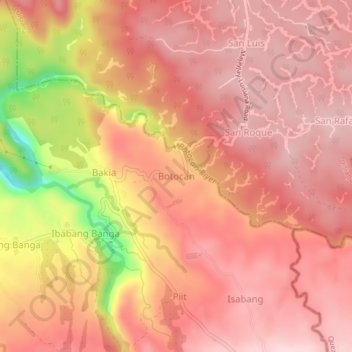
Name: Botocan topographic map, elevation, terrain.

Location: Botocan, Majayjay, Laguna, Calabarzon, 4006, Philippines (14.13532 121.47951 14.17532 121.51951)

Average elevation: 343 m

Minimum elevation: 152 m

Maximum elevation: 410 m

Other topographic maps

Click on a map to view its topography, its elevation and its terrain.

Malinao River

Philippines > Laguna > Majayjay > Rizal

Average elevation: 391 m

Gear up for your next adventure:

💧Hydration Reservoirs - Convenient water bladders for hands-free drinking on the move
🔦Keychain LED Torches - Emergency backup light for finding gear in your pack
🧺Ultralight Dry Bags - Organize and waterproof your gear inside your rucksack
📸Action Camera Chest Mounts - Record your ascent following topographic paths hands-free
🎒Hiking Backpacks - Comfortable backpacks for day hikes and multi-day treks

As an Amazon Associate, this site earns from qualifying purchases at no extra cost to you.