
Make a donation
Gear up for your next adventure:
As an Amazon Associate, this site earns from qualifying purchases at no extra cost to you.
Lavagnac topographic map
Click on the map to display elevation.
Make a donation
Gear up for your next adventure:
As an Amazon Associate, this site earns from qualifying purchases at no extra cost to you.
About this map
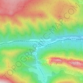
Name: Lavagnac topographic map, elevation, terrain.
Average elevation: 688 m
Minimum elevation: 393 m
Maximum elevation: 1,070 m
Make a donation
Gear up for your next adventure:
As an Amazon Associate, this site earns from qualifying purchases at no extra cost to you.
Other topographic maps
Click on a map to view its topography, its elevation and its terrain.
Puilaurens
France > Occitanie > Aude > Puilaurens
Sur le plan historique et culturel, la commune fait partie du Pays de Sault, un plateau situé entre 990 et 1310 mètres d'altitude fortement boisé. Exposée à un climat océanique altéré, elle est drainée par la Boulzane et par divers autres petits cours d'eau. La commune possède un patrimoine naturel…
Average elevation: 784 m