Geolocate

Boltaña topographic map

Click on the map to display elevation.

About this map

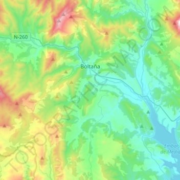
Name: Boltaña topographic map, elevation, terrain.

Location: Boltaña, Sobrarbe, Huesca, Aragon, Spain (42.33969 -0.13006 42.50286 0.11904)

Average elevation: 860 m

Minimum elevation: 507 m

Maximum elevation: 1,884 m

Gear up for your next adventure:

🥤Hydration Bladders - Hands-free hydration systems for backpacks
🧊Insulated Flasks - Keeps drinks hot or cold during hikes
🥼Base Layers - Thermal base layers for temperature regulation
🚶Walking Pedometers - Simple distance tracking for casual trail walkers
🧣Neck Gaiters - Versatile protection against wind and cold

As an Amazon Associate, this site earns from qualifying purchases at no extra cost to you.