
Solvang topographic map
Click on the map to display elevation.
About this map
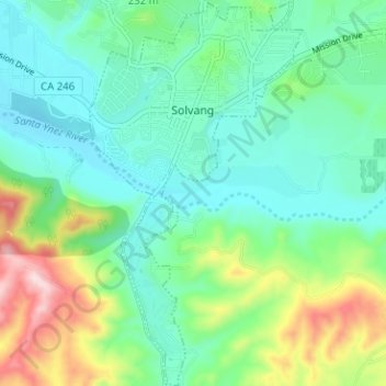
Name: Solvang topographic map, elevation, terrain.
Location: Solvang, Santa Barbara County, California, United States (34.55889 -120.15491 34.61077 -120.11992)
Average elevation: 193 m
Minimum elevation: 102 m
Maximum elevation: 442 m
Other topographic maps
Click on a map to view its topography, its elevation and its terrain.
Vandenberg Village
United States > California > Santa Barbara County > Lompoc
Average elevation: 132 m
North Santa Maria
United States > California > Santa Barbara County > Santa Maria
Average elevation: 65 m
Jalama Beach County Park
United States > California > Santa Barbara County > Jalama
Average elevation: 40 m
North Santa Maria
United States > California > Santa Barbara County > Santa Maria
Average elevation: 65 m
Shoreline Park
United States > California > Santa Barbara County > Santa Barbara
Average elevation: 21 m
Las Positas Meadows
United States > California > Santa Barbara County > Santa Barbara
Average elevation: 66 m