
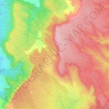
Le Jas d'Arbeau topographic map
Interactive map
Click on the map to display elevation.
About this map
Name: Le Jas d'Arbeau topographic map, elevation, terrain.
Average elevation: 188 m
Minimum elevation: 53 m
Maximum elevation: 269 m
Other topographic maps
Click on a map to view its topography, its elevation and its terrain.
Saragousse
France > Provence-Alpes-Côte d'Azur > Bouches-du-Rhône > Rognac
Saragousse, Rognac, Istres, Bouches-du-Rhône, Provence-Alpes-Côte d'Azur, France métropolitaine, 13340, France
Average elevation: 157 m