Geolocate

Chhapra topographic map

Click on the map to display elevation.

Chhapra

Chhapra is located at 25°47′05″N 84°43′39″E / 25.7848°N 84.7274°E / 25.7848; 84.7274. It has an average elevation of 36 metres (118 ft).

About this map

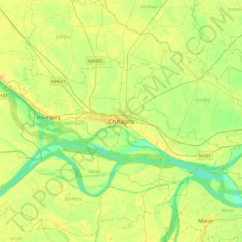
Name: Chhapra topographic map, elevation, terrain.

Location: Chhapra, Chapra, Saran, Bihar, 841300, India (25.61841 84.59145 25.93841 84.91145)

Average elevation: 54 m

Minimum elevation: 42 m

Maximum elevation: 64 m

Gear up for your next adventure:

🧵Survival Paracord - Multi-purpose cordage for emergency repairs and shelters
🎿Telescopic Trekking Poles - Reduces knee strain on steep topographic descents
GPS Outdoor Watches - Watches with GPS tracking for hiking and exploration
🧼Camping Hygiene Kits - Compact hygiene essentials for outdoor stays
❄️Walking Crampons - Added traction for icy slopes and winter peak bagging

As an Amazon Associate, this site earns from qualifying purchases at no extra cost to you.