Geolocate

Grand Prairie topographic map

Click on the map to display elevation.

About this map

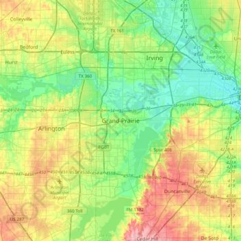
Name: Grand Prairie topographic map, elevation, terrain.

Location: Grand Prairie, Dallas County, Texas, 75051, United States (32.58596 -97.15778 32.90596 -96.83778)

Average elevation: 170 m

Minimum elevation: 120 m

Maximum elevation: 262 m

Gear up for your next adventure:

📕Outdoor Navigation Books - Learn traditional and modern navigation techniques
🗺️Ordnance Survey Maps - Essential paper maps for hiking across the UK national parks
🪓Outdoor Multitools - Versatile tools for hiking and camping
Lightweight Solo Tents - Backpacking tents designed for wild camping in the UK highlands
🧣Neck Gaiters - Protects against wind and sun on exposed ridges and peaks

As an Amazon Associate, this site earns from qualifying purchases at no extra cost to you.