
Yūbari topographic map
Interactive map
Click on the map to display elevation.
Yūbari
Die Entwicklung der Stadt fing in den 1890ern mit dem Start des Kohlebergbaus durch das Unternehmen Hokutan an, so dass die Einwohnerzahl bis 1920 auf 50.000 anstieg und 1960 seinen Höhepunkt mit 116.908 Einwohnern erreichte. Am 1. April 1943 erfolgte die Ernennung zur Shi.
About this map
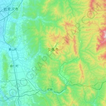
Name: Yūbari topographic map, elevation, terrain.
Location: Yūbari, 空知総合振興局, Präfektur Hokkaido, Japan (42.85980 141.90258 43.22526 142.33018)
Average elevation: 280 m
Minimum elevation: 8 m
Maximum elevation: 1,424 m