
Make a donation
Gear up for your next adventure:
As an Amazon Associate, this site earns from qualifying purchases at no extra cost to you.
Bovigny topographic map
Click on the map to display elevation.
Make a donation
Gear up for your next adventure:
As an Amazon Associate, this site earns from qualifying purchases at no extra cost to you.
About this map
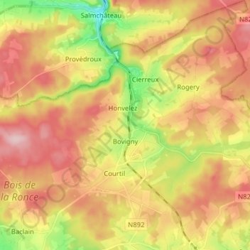
Name: Bovigny topographic map, elevation, terrain.
Location: Bovigny, Gouvy, Bastogne, Luxembourg, Wallonie, 6671, Belgique (50.18895 5.86832 50.27034 5.98527)
Average elevation: 487 m
Minimum elevation: 370 m
Maximum elevation: 584 m
Make a donation
Gear up for your next adventure:
As an Amazon Associate, this site earns from qualifying purchases at no extra cost to you.
Other topographic maps
Click on a map to view its topography, its elevation and its terrain.
Gouvy
Belgique > Luxembourg > Bastogne > Gouvy
La commune de Gouvy a une altitude moyenne de 488,25 m. Son point le plus haut se situe entre Langlire et Lomré et est à 592,5 m d’altitude. Son point le plus bas se situe à Rettigny avec 384 m d’altitude.
Average elevation: 469 m