
Venda Seca topographic map
Interactive map
Click on the map to display elevation.
About this map
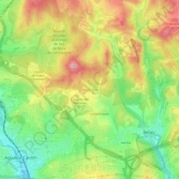
Name: Venda Seca topographic map, elevation, terrain.
Average elevation: 197 m
Minimum elevation: 112 m
Maximum elevation: 289 m
Other topographic maps
Click on a map to view its topography, its elevation and its terrain.
Serra de Casal de Cambra
Portugal > Lisboa > Queluz e Belas > Belas
Serra de Casal de Cambra, Belas, Queluz e Belas, Sintra, Lisboa, 2605-197, Portugal
Average elevation: 230 m