
Thank you for supporting this site ❤️
Make a donation
Make a donation
Gear up for your next adventure:
As an Amazon Associate, this site earns from qualifying purchases at no extra cost to you.
Gachie topographic map
Click on the map to display elevation.
Thank you for supporting this site ❤️
Make a donation
Make a donation
Gear up for your next adventure:
As an Amazon Associate, this site earns from qualifying purchases at no extra cost to you.
About this map
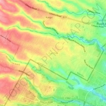
Name: Gachie topographic map, elevation, terrain.
Location: Gachie, Kihara ward, Kabete, Kiambu, 43563, Kenya (-1.23676 36.74617 -1.19676 36.78617)
Average elevation: 1,777 m
Minimum elevation: 1,712 m
Maximum elevation: 1,830 m
Thank you for supporting this site ❤️
Make a donation
Make a donation
Gear up for your next adventure:
As an Amazon Associate, this site earns from qualifying purchases at no extra cost to you.