
Bebra topographic map
Interactive map
Click on the map to display elevation.
About this map
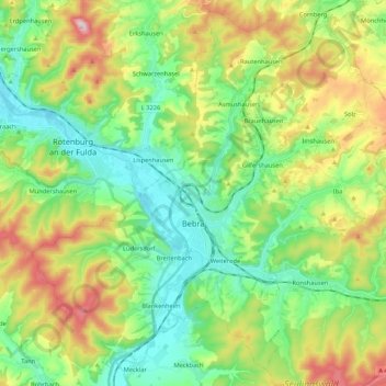
Name: Bebra topographic map, elevation, terrain.
Location: Bebra, Landkreis Hersfeld-Rotenburg, Hesse, 36179, Germany (50.91701 9.70473 51.04239 9.91998)
Average elevation: 312 m
Minimum elevation: 180 m
Maximum elevation: 541 m
Other topographic maps
Click on a map to view its topography, its elevation and its terrain.
Hohenroda
Germany > Hesse > Landkreis Hersfeld-Rotenburg
Hohenroda, Landkreis Hersfeld-Rotenburg, Hesse, 36284, Germany
Average elevation: 341 m
Heringen (Werra)
Germany > Hesse > Landkreis Hersfeld-Rotenburg
Heringen (Werra), Landkreis Hersfeld-Rotenburg, Hesse, 36266, Germany
Average elevation: 294 m
Heenes
Germany > Hesse > Landkreis Hersfeld-Rotenburg
Heenes, Bad Hersfeld, Landkreis Hersfeld-Rotenburg, Hesse, Germany
Average elevation: 310 m
Bad Hersfeld
Germany > Hesse > Landkreis Hersfeld-Rotenburg
Bad Hersfeld, Landkreis Hersfeld-Rotenburg, Hesse, 36251, Germany
Average elevation: 281 m
Haunetal
Germany > Hesse > Landkreis Hersfeld-Rotenburg
Haunetal, Landkreis Hersfeld-Rotenburg, Hesse, 36166, Germany
Average elevation: 313 m