
Karnala topographic map
Interactive map
Click on the map to display elevation.
About this map
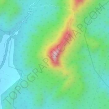
Name: Karnala topographic map, elevation, terrain.
Average elevation: 130 m
Minimum elevation: 19 m
Maximum elevation: 409 m
Other topographic maps
Click on a map to view its topography, its elevation and its terrain.
Panvel
India > Maharashtra > Panvel Taluka
Matheran is a hill station and a municipal council in the Raigad district in the Indian state of Maharashtra. It is a hill station in Karjat Tahsil and is also the smallest hill station in India. It is located on the Western Ghats range at an elevation of around 800 m (2,625 feet) above sea level. It is…
Average elevation: 41 m