Geolocate

Schwalbach am Taunus topographic map

Interactive map

Click on the map to display elevation.

About this map

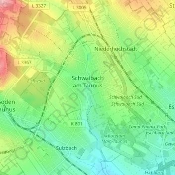
Name: Schwalbach am Taunus topographic map, elevation, terrain.

Location: Schwalbach am Taunus, Main-Taunus-Kreis, Hesse, 65824, Germany (50.12593 8.50941 50.16861 8.56402)

Average elevation: 155 m

Minimum elevation: 108 m

Maximum elevation: 234 m

Other topographic maps

Click on a map to view its topography, its elevation and its terrain.

Kriftel

Germany > Hesse > Main-Taunus-Kreis

Average elevation: 123 m

Sulzbach (Taunus)

Germany > Hesse > Main-Taunus-Kreis

Average elevation: 140 m

Hofheim am Taunus

Germany > Hesse > Main-Taunus-Kreis

Hofheim was also mentioned in the Topographia Hassiae. Which said that.

Average elevation: 198 m

Eschborn

Germany > Hesse > Main-Taunus-Kreis

Eschborn provides expansive views of the Taunus mountain ranges, especially the 'Altkönig' and behind it the 'Feldberg' up to elevations of around 880 m above sealevel. From Eschborn to the north there are numerous hiking and biking trails leading up to these green mountain zones. In winter, along and up…

Average elevation: 146 m

Bad Soden am Taunus

Germany > Hesse > Main-Taunus-Kreis

Average elevation: 216 m

Hochheim

Germany > Hesse > Main-Taunus-Kreis > Hochheim

Average elevation: 123 m