Geolocate

Kampung Tengah topographic map

Interactive map

Click on the map to display elevation.

About this map

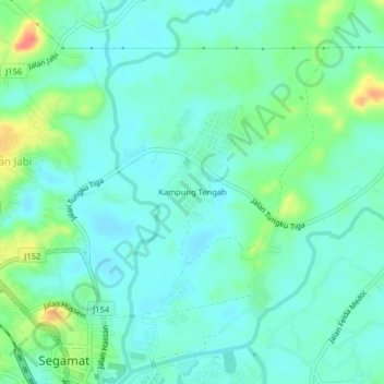
Name: Kampung Tengah topographic map, elevation, terrain.

Location: Kampung Tengah, Segamat, Johor, 85000, Malaysia (2.50996 102.80714 2.54996 102.84714)

Average elevation: 20 m

Minimum elevation: 6 m

Maximum elevation: 62 m

Other topographic maps

Click on a map to view its topography, its elevation and its terrain.

Sungai Segamat

Malaysia > Johor > Segamat > Kampung Jawa

Average elevation: 18 m

Sungai Segamat

Malaysia > Johor > Segamat

Average elevation: 17 m

Kampung Abdullah

Malaysia > Johor > Segamat

Average elevation: 16 m

Pekan Ayer Panas

Malaysia > Johor > Segamat > Pekan Ayer Panas

Average elevation: 65 m

Taman Yayasan

Malaysia > Johor > Segamat

Average elevation: 27 m

Kampung Jawa

Malaysia > Johor > Segamat

Average elevation: 16 m