
Make a donation
Gear up for your next adventure:
As an Amazon Associate, this site earns from qualifying purchases at no extra cost to you.
Temperance topographic map
Click on the map to display elevation.
Make a donation
Gear up for your next adventure:
As an Amazon Associate, this site earns from qualifying purchases at no extra cost to you.
About this map
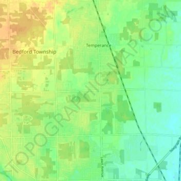
Name: Temperance topographic map, elevation, terrain.
Location: Temperance, Monroe County, Michigan, 48182, United States (41.73568 -83.58838 41.79377 -83.55395)
Average elevation: 191 m
Minimum elevation: 179 m
Maximum elevation: 205 m
Make a donation
Gear up for your next adventure:
As an Amazon Associate, this site earns from qualifying purchases at no extra cost to you.
Other topographic maps
Click on a map to view its topography, its elevation and its terrain.
Golfcrest
United States > Michigan > Monroe County > Frenchtown Charter Township
Average elevation: 181 m
River Raisin
United States > Michigan > Monroe County > Raisinville Township > Grape
Average elevation: 192 m
Make a donation
Gear up for your next adventure:
As an Amazon Associate, this site earns from qualifying purchases at no extra cost to you.