
Make a donation
Gear up for your next adventure:
As an Amazon Associate, this site earns from qualifying purchases at no extra cost to you.
Sonsón topographic map
Click on the map to display elevation.
Make a donation
Gear up for your next adventure:
As an Amazon Associate, this site earns from qualifying purchases at no extra cost to you.
About this map
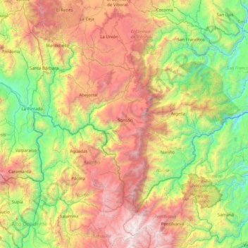
Name: Sonsón topographic map, elevation, terrain.
Average elevation: 1,688 m
Minimum elevation: 365 m
Maximum elevation: 3,803 m
Make a donation
Gear up for your next adventure:
As an Amazon Associate, this site earns from qualifying purchases at no extra cost to you.
Other topographic maps
Click on a map to view its topography, its elevation and its terrain.
Rionegro
Colombia > Antioquia > Rionegro
The city of Rionegro is located at 6°9′18″N 75°22′48″W / 6.15500°N 75.38000°W / 6.15500; -75.38000, at an average elevation of 2,125 metres (6,972 ft) above sea level. The average annual precipitation varies between 1,800 and 2,500 millimetres (71 and 98 in) with an average temperature of…
Average elevation: 2,232 m