
Make a donation
Gear up for your next adventure:
As an Amazon Associate, this site earns from qualifying purchases at no extra cost to you.
Montijo topographic map
Click on the map to display elevation.
Make a donation
Gear up for your next adventure:
As an Amazon Associate, this site earns from qualifying purchases at no extra cost to you.
About this map
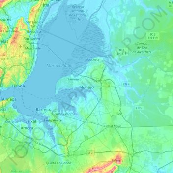
Name: Montijo topographic map, elevation, terrain.
Average elevation: 28 m
Minimum elevation: -3 m
Maximum elevation: 237 m
Make a donation
Gear up for your next adventure:
As an Amazon Associate, this site earns from qualifying purchases at no extra cost to you.
Other topographic maps
Click on a map to view its topography, its elevation and its terrain.
Make a donation
Gear up for your next adventure:
As an Amazon Associate, this site earns from qualifying purchases at no extra cost to you.
Make a donation
Gear up for your next adventure:
As an Amazon Associate, this site earns from qualifying purchases at no extra cost to you.
Seixal
Although the municipal population continued to grow with development, after the 1970s there was a boom in the population, due to improvements in accessibility and mobility, principally due to public transport, its location to Lisbon and installation of economic activities within the territory. This growth…
Average elevation: 38 m
Make a donation
Gear up for your next adventure:
As an Amazon Associate, this site earns from qualifying purchases at no extra cost to you.
Make a donation
Gear up for your next adventure:
As an Amazon Associate, this site earns from qualifying purchases at no extra cost to you.
Make a donation
Gear up for your next adventure:
As an Amazon Associate, this site earns from qualifying purchases at no extra cost to you.
Make a donation
Gear up for your next adventure:
As an Amazon Associate, this site earns from qualifying purchases at no extra cost to you.
Make a donation
Gear up for your next adventure:
As an Amazon Associate, this site earns from qualifying purchases at no extra cost to you.
Seixal
Although the municipal population continued to grow with development, after the 1970s there was a boom in the population, due to improvements in accessibility and mobility, principally due to public transport, its location to Lisbon and installation of economic activities within the territory. This growth…
Average elevation: 38 m
Grândola
Significant civic and religious infrastructure was developed after the town's elevation, including the construction of a town hall, a jail, a pillory, a hospital, a Santa Casa da Misericórdia, and several chapels and churches. A common granary was established in 1579 to provide low-interest seed loans to poor…
Average elevation: 69 m
Make a donation
Gear up for your next adventure:
As an Amazon Associate, this site earns from qualifying purchases at no extra cost to you.
Make a donation
Gear up for your next adventure:
As an Amazon Associate, this site earns from qualifying purchases at no extra cost to you.