
Tamda Noumercid topographic map
Interactive map
Click on the map to display elevation.
About this map
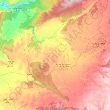
Name: Tamda Noumercid topographic map, elevation, terrain.
Average elevation: 1,254 m
Minimum elevation: 551 m
Maximum elevation: 1,763 m
Other topographic maps
Click on a map to view its topography, its elevation and its terrain.
Zaouiat Ahansal
Zaouiat Ahansal, caïdat de Zaouïat Ahansal, cercle d'Azilal, Province d'Azilal, Béni Mellal-Khénifra, 22002, Maroc
Average elevation: 2,325 m
Amezri
Maroc > cercle d'Azilal > Zaouiat Ahansal
Amezri, Zaouiat Ahansal, caïdat de Zaouïat Ahansal, cercle d'Azilal, Province d'Azilal, Béni Mellal-Khénifra, 22002, Maroc
Average elevation: 1,777 m