
Accokeek topographic map
Interactive map
Click on the map to display elevation.
About this map
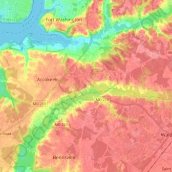
Name: Accokeek topographic map, elevation, terrain.
Average elevation: 46 m
Minimum elevation: -3 m
Maximum elevation: 74 m
Other topographic maps
Click on a map to view its topography, its elevation and its terrain.
Peace Cross Historic Site
États-Unis d'Amérique > Maryland > Prince George's County > Bladensburg
Peace Cross Historic Site, 4500, Bladensburg, Prince George's County, Maryland, 20710, États-Unis d'Amérique
Average elevation: 15 m
Manchester Estates
États-Unis d'Amérique > Maryland > Prince George's County > Camp Springs
Manchester Estates, Camp Springs, Prince George's County, Maryland, 20746, États-Unis d'Amérique
Average elevation: 75 m