
Make a donation
Gear up for your next adventure:
As an Amazon Associate, this site earns from qualifying purchases at no extra cost to you.
Mokopane topographic map
Click on the map to display elevation.
Make a donation
Gear up for your next adventure:
As an Amazon Associate, this site earns from qualifying purchases at no extra cost to you.
About this map
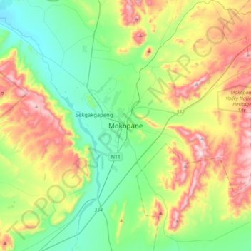
Name: Mokopane topographic map, elevation, terrain.
Average elevation: 1,285 m
Minimum elevation: 1,008 m
Maximum elevation: 1,816 m
Make a donation
Gear up for your next adventure:
As an Amazon Associate, this site earns from qualifying purchases at no extra cost to you.
Other topographic maps
Click on a map to view its topography, its elevation and its terrain.
Modimolle Ward 2
South Africa > Limpopo > Waterberg District Municipality > Modimolle Local Municipality
Average elevation: 1,264 m
Mokolo Dam
South Africa > Limpopo > Waterberg District Municipality > Lephalale Local Municipality
Average elevation: 1,037 m
Marakele National Park
South Africa > Limpopo > Waterberg District Municipality
Average elevation: 1,333 m
Thabazimbi Ward 4
South Africa > Limpopo > Waterberg District Municipality > Thabazimbi Local Municipality
Average elevation: 1,101 m
Make a donation
Gear up for your next adventure:
As an Amazon Associate, this site earns from qualifying purchases at no extra cost to you.
Mogalakwena
South Africa > Limpopo > Waterberg District Municipality > Mogalakwena Local Municipality
Average elevation: 855 m
Mookgopong Local Municipality
South Africa > Limpopo > Waterberg District Municipality
Average elevation: 1,145 m
Lapalala Wilderness Reserve
South Africa > Limpopo > Waterberg District Municipality
Average elevation: 1,136 m
Mabalingwe Nature Reserve
South Africa > Limpopo > Waterberg District Municipality > Bela Bela Local Municipality
Average elevation: 1,291 m
Make a donation
Gear up for your next adventure:
As an Amazon Associate, this site earns from qualifying purchases at no extra cost to you.
Bela Bela Local Municipality
South Africa > Limpopo > Waterberg District Municipality
Average elevation: 1,143 m
Doorndraai Dam
South Africa > Limpopo > Waterberg District Municipality > Mookgopong Local Municipality
Average elevation: 1,258 m
Mogalakwena Local Municipality
South Africa > Limpopo > Waterberg District Municipality
Average elevation: 1,167 m
Modimolle Local Municipality
South Africa > Limpopo > Waterberg District Municipality
Average elevation: 1,273 m
Make a donation
Gear up for your next adventure:
As an Amazon Associate, this site earns from qualifying purchases at no extra cost to you.
Welgevonden Nature Reserve
South Africa > Limpopo > Waterberg District Municipality > Mokopane
Average elevation: 1,356 m
Mogalakwena Local Municipality
South Africa > Limpopo > Waterberg District Municipality
Average elevation: 1,167 m
Modimolle Local Municipality
South Africa > Limpopo > Waterberg District Municipality
Average elevation: 1,273 m
Mogalakwena River
South Africa > Limpopo > Waterberg District Municipality > Mokopane
Average elevation: 1,078 m
Make a donation
Gear up for your next adventure:
As an Amazon Associate, this site earns from qualifying purchases at no extra cost to you.
Lephalale Local Municipality
South Africa > Limpopo > Waterberg District Municipality
Average elevation: 991 m
Thabazimbi Local Municipality
South Africa > Limpopo > Waterberg District Municipality
Average elevation: 1,010 m
Lapalala Wilderness Reserve
South Africa > Limpopo > Waterberg District Municipality
Average elevation: 1,136 m
Modimolle Local Municipality
South Africa > Limpopo > Waterberg District Municipality
Average elevation: 1,273 m
Make a donation
Gear up for your next adventure:
As an Amazon Associate, this site earns from qualifying purchases at no extra cost to you.
Lapalala Wilderness Reserve
South Africa > Limpopo > Waterberg District Municipality
Average elevation: 1,136 m
Mogalakwena Ward 16
South Africa > Limpopo > Waterberg District Municipality > Mogalakwena Local Municipality
Average elevation: 1,190 m
Nylsvley Nature Reserve
South Africa > Limpopo > Waterberg District Municipality > Mookgopong Local Municipality
Average elevation: 1,104 m